Self-driving cars and advanced driver assistance systems (ADAS) are often the first applications that come to mind when we think of LiDAR and 3D technologies. These tools enable vehicles to understand their surroundings in real time. However, cutting-edge technologies like LiDAR and 3D imaging are now being applied in various areas beyond roads and vehicles.
Today, they are being used to measure, map, and monitor the world with a level of detail that was once hard to achieve. You can think of it like taking a high-resolution scan of the real world, capturing every surface and detail to create a complete digital version of a physical space.
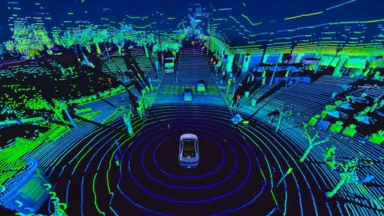
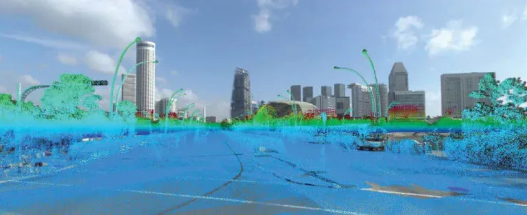
LiDAR data helps autonomous vehicles understand their environment. (Source)
From farmlands to factories, these technologies are reshaping how industries operate. For instance, in agriculture, farmers can use 3D maps to assess soil health and plan irrigation with precision. Likewise, archaeologists can scan heritage sites without touching a single stone, ensuring that delicate structures remain undisturbed during observation.
This approach is also being used in logistics and warehousing, where real-time 3D visualization helps track inventory and improve storage layouts. In addition to this, in construction, 3D mapping can reveal design flaws and reduce errors before on-site work begins.
While autonomous vehicles may still be the most familiar example, the impact of LiDAR and 3D tools is growing across many industries. In this article, we’ll explore how LiDAR and 3D imaging are changing the way we see, understand, and interact with the physical world. Let’s get started!
LiDAR, which stands for Light Detection and Ranging, is a technology used to measure distances and create virtual maps of physical environments. It works by sending out rapid pulses of laser light and measuring how long each pulse takes to bounce back after hitting a surface. These time measurements tell the system how far away each object is.
By collecting thousands of these distance readings, LiDAR systems generate what’s known as a 3D point cloud – a digital model made up of millions of points that represent the shape and position of real-world objects. These point clouds can capture features like buildings, roads, terrain, and vegetation with high resolution and accuracy.
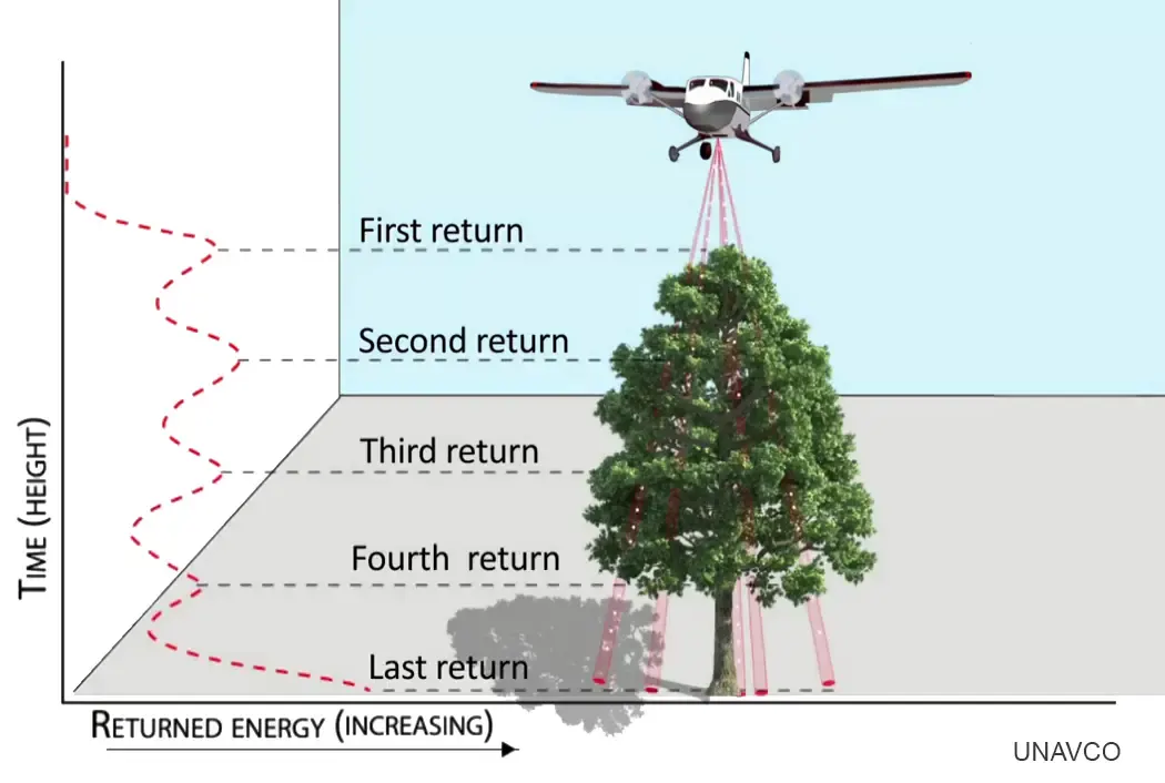
How Lidar Works to Create 3D Point Clouds. (Source)
Interestingly, LiDAR is often used alongside cameras, GPS, and motion sensors to give machines a more complete understanding of their surroundings. Cameras add visual detail, GPS provides precise location, and sensors like IMUs track movement and direction. AI models can then pull all this data together to recognize objects and understand what’s happening in an environment.
Now that we have a better understanding of what LiDAR technology is, let’s dive into various applications of LiDAR and 3D point clouds across different industries.
Every construction project, like a skyscraper, bridge, or urban development, starts with a bold vision, but turning plans into reality isn’t always straightforward. Inaccurate site data can lead to delays and costly rework. To avoid this, teams are increasingly using LiDAR and 3D mapping to capture precise measurements and keep projects on track.
From site planning to ongoing progress tracking, LiDAR makes it possible for construction teams to work more accurately and efficiently. It provides precise data through detailed surveys, terrain mapping, and elevation analysis before construction even begins, reducing surprises and lowering the risk of costly mistakes. In fact, to speed up this process, many teams are now using drones equipped with LiDAR to scan large or complex sites.
An interesting example is the construction of Hawaii’s Daniel K. Inouye International Airport. Drone-based LiDAR was used to track ground movement and map surface contours in real-time. The system captured accurate elevation data across the site, which helped teams monitor grading progress and compare actual ground levels to the project design.
Weekly scans were processed and converted into 3D point clouds and integrated into planning software to keep digital models up to date. By using LiDAR throughout the project, teams were able to improve speed and accuracy while reducing the need for manual rework.
Managing a farm involves more than just planting and harvesting. From unpredictable weather to optimizing every resource, farmers and forest rangers need to know exactly what’s happening across every acre, often in remote or hard-to-reach areas. Traditional methods simply can’t keep up with this scale or speed.
That’s where LiDAR comes in. In both agriculture and forestry, it provides a detailed 3D view of features such as plant height, terrain, and crop health. This helps with tasks such as analyzing canopy structure and identifying potential yield issues before they worsen.
With 3D point cloud data, farmers can visualize field variations in real-time and adjust their planting strategies across large areas. As precision agriculture continues to grow, tools like 3D imaging are becoming essential for understanding what’s happening on the ground and making better choices faster.
Take, for example, a 4.4-hectare farmland in Yorkshire, UK, where drones with LiDAR systems were used to scan individual trees. This solution captured detailed data, including canopy height, trunk diameter, and biomass, using a dense 3D point cloud. The data was then used to assess fuel load, analyze drainage patterns, and monitor tree health to support fire prevention and harvest planning.
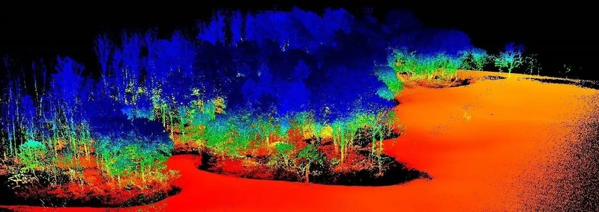
Drones Using LiDAR to Capture Detailed Forest Data. (Source)
Preserving the past isn’t always as simple as taking a photograph or sketching a map. Many historical sites are fragile or hidden deep within remote landscapes. Also, the threats of weather, time, and nearby development can mean many of these places are at risk of being lost before they can be fully understood.
LiDAR offers a way to scan and document these environments without physical contact. It can be used to create detailed 3D scans of ruins, cave systems, and ancient structures. These scans help build accurate digital records and support virtual reconstructions that can be shared and studied from anywhere.
For instance, LiDAR was used to reveal an 18th-century Portuguese colonial settlement near Brazil. The scans revealed roads, canals, church foundations, and fortifications that were hidden beneath a thick forest cover. This data was turned into a 3D point cloud that matched known historical records.
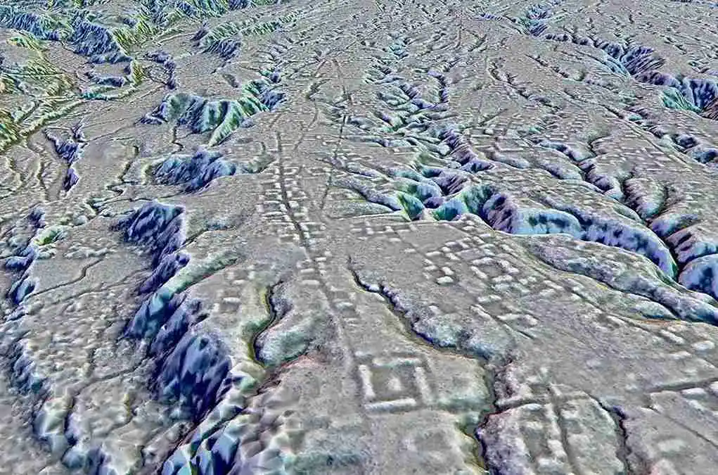
A 3D Map of the Ancient Streets in Ecuador’s Amazon Rainforest (Source)
Cities are always changing. New buildings rise, traffic patterns shift, and neighborhoods grow. At the same time, older infrastructure needs care and attention. That’s why urban development requires professionals to respond to challenges with accuracy and speed. But traditional tools often fall short. They can be outdated or incomplete and may not show what is really happening on the ground.
LiDAR helps meet these needs. By capturing high-resolution spatial data, it allows planners to map streets, bridges, parks, utilities, and other infrastructure with precision. This information is used to create 3D digital models that reflect real-world environments in detail. With these models, planners can monitor traffic flow, track pedestrian activity, and design more efficient transportation and utility systems.
Many cities now rely on LiDAR-generated 3D point clouds to simulate how urban systems respond to real-world concerns such as flooding, traffic congestion, and infrastructure stress. In Singapore, for example, the Virtual Twin project uses LiDAR and street-level imagery to build a complete 3D model of the city. This model helps simulate wind flow, sunlight exposure, and flood risk, supporting more effective emergency response and long-term urban planning.
LiDAR-Powered 3D Model of Singapore. (Source)
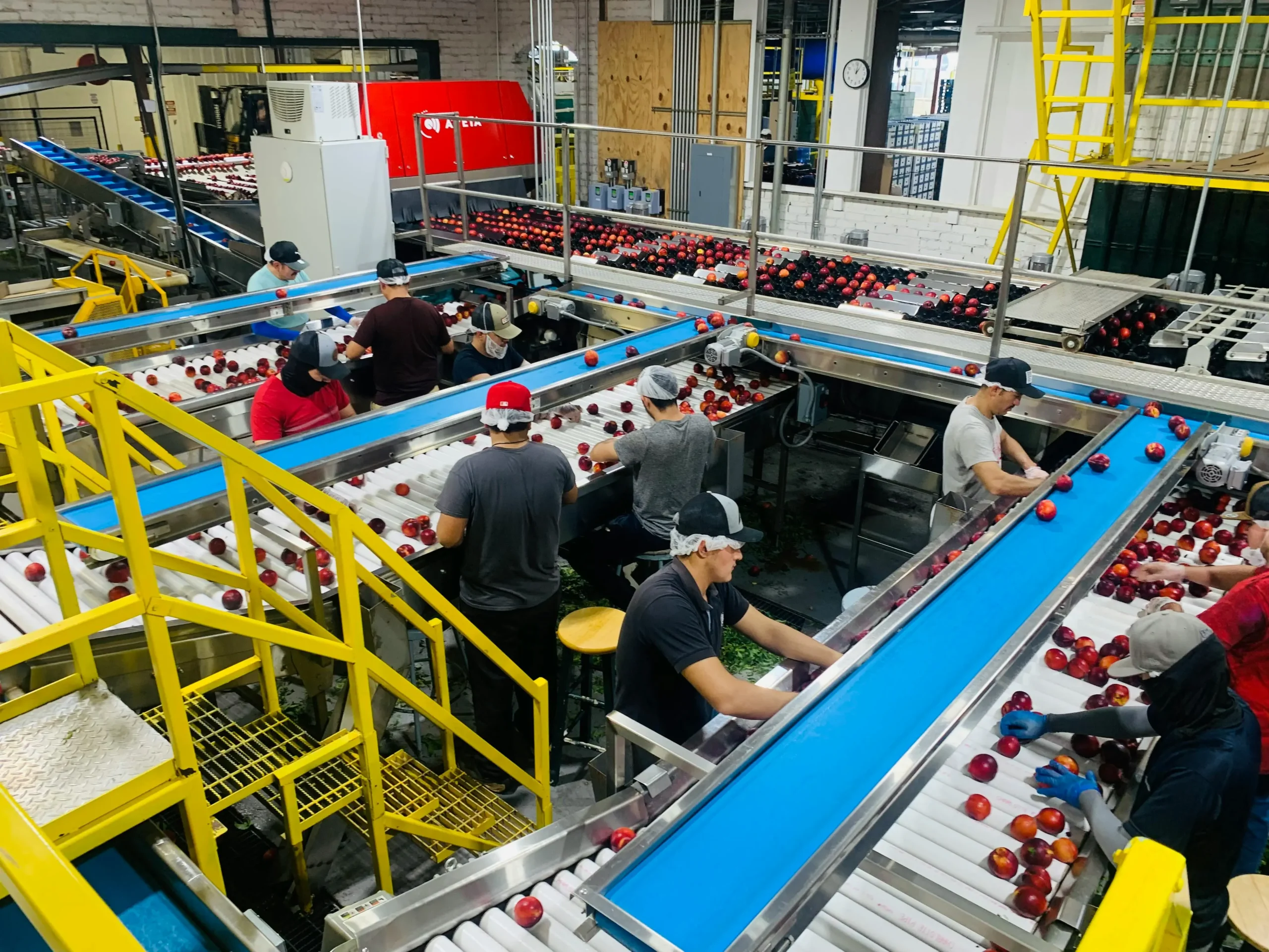
Efficient warehousing and logistics are essential in today’s fast-moving supply chains. Businesses need tools that help manage complex indoor spaces, track inventory accurately, and reduce manual errors as operations become more automated.
LiDAR is increasingly being used in warehouses and factories to support this shift. It guides autonomous forklifts and robots by providing real-time 3D perception. At the same time, 3D point cloud data supports live inventory tracking and helps teams make better use of space.
A good example of real-time 3D perception is mobile robots being equipped with LiDAR and SLAM to move parts across a production floor. SLAM, or Simultaneous Localization and Mapping, robots can map unfamiliar spaces and track their location at the same time.
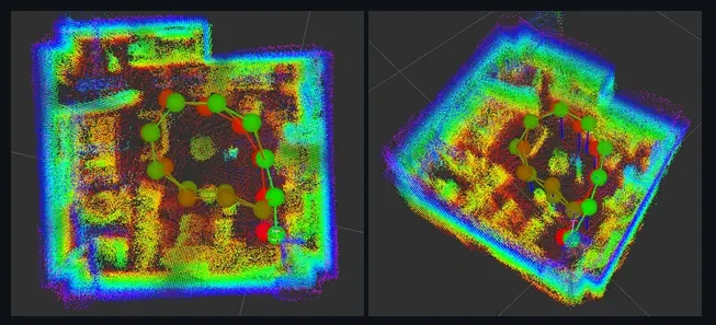
LiDAR and SLAM can be used for indoor route planning. (Source)
LiDAR and 3D imaging are steadily advancing. These tools are becoming easier to use, more affordable, and much more powerful than they were just a few years ago. As technology evolves, sensors are getting smaller and more intelligent, making LiDAR and 3D imaging more common in everyday tasks across industries.
Recent developments like Aeva Atlas Ultra, a 4D LiDAR sensor, can measure both distance and speed, adding a new layer of precision to applications. Similarly, Kyocera, a global electronics and sensor manufacturer, has developed a parallax-free sensor that combines LiDAR and camera data to deliver real-time depth information with improved accuracy.
LiDAR and 3D imaging are moving beyond specialized applications and becoming integral to mainstream technology. These tools aren’t limited to industrial settings, and are now being used in consumer devices, disaster management systems, and urban infrastructure. As more industries adopt these tools, the need for clear and accurate 3D data continues to grow.
At Objectways, we work with teams who rely on 3D point clouds, LiDAR annotations, and high-quality 3D mapping data to support real-world projects. Whether you’re building autonomous systems, training models, or improving how your tools understand physical environments, we can support your data workflows.
If you’re working with LiDAR or 3D data, reach out to see how Objectways can help with reliable data collection and annotation.
3D imaging is used to create accurate digital representations of physical environments for analysis, planning, or visualization.

Learn how computer vision for quality inspection helps detect defects, improve product accuracy, and maintain quality control in production lines.

Learn how computer vision in transportation enhances safety, efficiency, and sustainability through real-time traffic insights and smart mobility systems.