Table of content
Choosing your labeling modality
Why High-Quality labeling is important
Best Practices to Manage Large Scale Lidar 3D Point Cloud Labeling Projects
Summary
Precision Matters: The Importance of High-Quality Lidar 3D Point Cloud Labeling
Lidar (which stands for Light Detection and Ranging) is a type of 3D sensing technology that uses laser light to measure distances and create detailed 3D maps of objects and environments. Lidar has a wide range of applications, including self-driving cars, robotics, virtual reality, and geospatial mapping.
Lidar works by emitting laser light pulses and measuring the time it takes for the light to bounce back after hitting an object or surface. This data is then used to create a precise 3D map of the surrounding environment, with detailed information about the size, shape, and distance of objects within the map. Lidar sensors can vary in their range and resolution, with some sensors able to measure distances up to several hundred meters, and others able to detect fine details as small as a few centimeters.
One of the primary applications of lidar is in autonomous vehicles, where lidar sensors can be used to create a detailed 3D map of the surrounding environment, allowing the vehicle to detect and avoid obstacles in real-time. Lidar is also used in robotics for navigation and obstacle avoidance, and in virtual reality for creating immersive, 3D environments.
In addition, lidar is used in geospatial mapping and surveying, where it can be used to create highly accurate 3D maps of terrain and buildings for a variety of applications, including urban planning, disaster response, and natural resource management.
Overall, lidar is a powerful and versatile technology that is driving advances in a wide range of fields, from autonomous vehicles to robotics to geospatial mapping.
Choosing your labeling modality
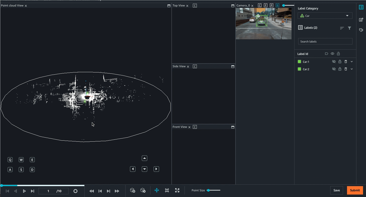
Object Tracking
Computer vision techniques are often used in combination with lidar 3D point cloud data to extract information and insights from the data. Here are some of the different computer vision techniques that can be used with lidar 3D point cloud data:
- Object detection and recognition:-This involves using computer vision algorithms to detect and identify objects within the point cloud data, such as cars, buildings, and trees. Object detection and recognition can be useful for a wide range of applications, from urban planning to autonomous driving.
- Object tracking:-This involves tracking the movement and trajectory of objects within the point cloud data over time. Object tracking can be used for applications such as crowd monitoring or autonomous vehicle navigation.
- Segmentation:-This involves dividing the point cloud data into different segments based on the properties of the points, such as color or reflectivity. Segmentation can be used to identify regions of interest within the data, such as road surfaces or building facades.
Overall, these computer vision techniques can help to extract valuable information and insights from lidar 3D point cloud data and enable a wide range of applications and use cases. By combining lidar data with computer vision techniques, it is possible to create highly accurate and detailed 3D models of objects and environments, with a wide range of potential applications.
Why High-Quality labeling is important
High-quality lidar 3D point cloud labels are important for creating accurate and reliable 3D models of objects and environments. Here are some reasons why high-quality lidar 3D point cloud labels matter for a high-quality model:
- Accuracy:-High-quality lidar 3D point cloud labels ensure that objects are accurately and consistently identified and labeled within the data. This is important for applications such as autonomous vehicles or robotics, where accurate and reliable information about objects in the environment is critical.
- Consistency:-High-quality lidar 3D point cloud labels ensure that objects are labeled consistently across the data, with no variations in naming or identification. This is important for applications such as object detection or segmentation, where consistent labels are necessary for accurate and reliable results.
- Completeness:-High-quality lidar 3D point cloud labels ensure that all objects within the data are identified and labeled, with no missing or incomplete information. This is important for applications such as geospatial mapping or urban planning, where complete and comprehensive information about objects in the environment is necessary.
- Cost-effectiveness:-While high-quality lidar 3D point cloud labels may be more expensive to acquire or process initially, they can actually be more cost-effective in the long run, as they may require fewer resources to process or analyze and may be more suitable for a wider range of applications.
Overall, high-quality lidar 3D point cloud labels are critical for creating accurate and reliable 3D models of objects and environments, with a wide range of potential applications and benefits. By investing in high-quality labeling and processing, it is possible to create more accurate, detailed, and valuable 3D models that can be used in a wide range of applications, from autonomous vehicles to urban planning to robotics.
Best Practices to Manage Large Scale Lidar 3D Point Cloud Labeling Projects
Planning your lidar 3D point cloud labeling project is an important step in ensuring that the project is completed on time, on budget, and with the desired level of quality. Here are some key considerations to keep in mind when planning your lidar 3D point cloud labeling project:
- Project scope:-Define the scope of the project, including the size of the dataset, the types of objects to be labeled, and the level of detail required. This will help to ensure that the project is focused and well-defined.
- Labeling requirements:-Define the labeling requirements for the project, including the labeling schema, the labeling accuracy, and the level of detail required. This will help to ensure that the labeling process is consistent and produces high-quality results.
- Labeling team:-Define the size and composition of the labeling team, including the number of labelers, their expertise, and their availability. Objectways can provide 1000s of trained Lidar labeling experts to match the throughput demand.
- Tools and resources:-Identify the tools and resources required for the labeling project, including software, hardware, and data storage. This will help to ensure that the labeling process is efficient and that the results are consistent and of high quality.
- Timeline and budget:-Define the timeline and budget for the labeling project, including the estimated time required for labeling, the cost of resources, and the expected deliverables. This will help to ensure that the project is completed on time and within budget.
- Use Pre-labeling or down sampling to Save Cost:-There are many SOTA models available for pre-labeling that can provide starting point for labeling to save human labeling cost. Other approach in object tracking is to down sample frames at lower rate to reduce labeling effort
Overall, careful planning is key to the success of any lidar 3D point cloud labeling project. By taking the time to define the scope, requirements, team, tools, timeline, and budget for the project, it is possible to ensure that the project is completed with the desired level of quality and within the allotted resources.
At Objectways, we have worked on 100s of Lidar 3D point Cloud labeling projects across Autonomous Vehicles, Robotics, Agriculture and Geospatial domains. Contact Objectways for planning your next Lidar 3D point cloud labeling project
- Lidar 3D Object Detection
- Computer Vision
- Autonomous Vehicle
- Self Driving Cars
- Tesla